5 Amazing Discoveries at Trailhead Bukit Banang: A Breathtaking Hiking Adventure
Introduction
Hey there, outdoor lovers! Have you heard about Trailhead Bukit Banang? If not, you’re in for a real treat. Nestled near Batu Pahat in Johor, Malaysia, this trail is a slice of paradise for hikers and nature enthusiasts. Stretching over 2 miles with an elevation gain of about 705.2 feet, Bukit Banang isn’t just a walk in the woods – it’s an adventure that challenges and rewards you in equal measure.
Rated as a hard trail, Bukit Banang is perfect for those who love a good challenge. The trail’s mix of rugged terrain and breathtaking views makes it a unique destination. Whether you’re in it for the physical challenge, the stunning panoramas, or a bit of both, Bukit Banang has got you covered.
In this blog, we’re going to dive deep into what makes Trailhead Bukit Banang a must-visit. We’ll explore everything from how to get there, what to expect on the trail, and even what’s waiting for you beyond the hike. So, tie up those laces, grab your water bottle, and let’s get started on this journey together!
Getting There: Navigating to Bukit Banang
So, you’re all geared up and ready to hit the trail. But wait, how do you get to this hiker’s haven? Whether you’re a local or flying in from afar, reaching Bukit Banang is part of the adventure.
By Car: If you’re starting from Kuala Lumpur, you’re in for a road trip! It’s a roughly 2 hour and 48-minute drive from Kuala Lumpur Terminal Bersepadu Selatan to Bukit Banang. The route is straightforward and a great way to experience the Malaysian countryside. Expect to spend around RM 45 – RM 70 for the journey.
For those coming from other regions, it’s best to punch in ‘Bukit Banang’ on your GPS for the most direct route. The roads leading to Bukit Banang are generally in good condition, offering a pleasant drive.
Parking and Entrance: Once you arrive, you’ll find parking spots conveniently located near the trailhead. Remember to arrive early during peak seasons to secure a spot!
Public Transport: If you’re opting for public transport, check local bus or train schedules to Batu Pahat, and from there, you can take a taxi or a local bus to the trailhead.
Remember, the journey is just as important as the destination, so enjoy the ride!
The Hike Itself: A Step-by-Step Guide
Now, let’s talk about the trail itself. Bukit Banang is a fascinating mix of natural beauty and physical challenge.
The Trail Description: The 2-mile trail is a journey through varied landscapes. You’ll trek through dense forests, rugged terrains, and open spaces that offer stunning views of the surrounding area. The trail has an elevation gain of about 705.2 ft, making it a challenging yet rewarding experience.
Difficulty Level and Duration: Rated as hard, this trail is a test of endurance and strength. It typically takes about [insert average duration] to complete, but this can vary depending on your pace and experience.
Best Times to Visit: The trail is open year-round, but the best time to visit is during the cooler months. This period offers the most comfortable hiking conditions and the clearest views. Always check the weather before setting out and start early to make the most of your day.
What to Bring: Essential items include water, snacks, a first-aid kit, and a camera for those breathtaking views. Wear comfortable hiking shoes and weather-appropriate clothing.
What to See and Do: Attractions on the Trail
Bukit Banang isn’t just a trek; it’s a treasure trove of natural wonders and surprises. Here’s what you can look forward to:
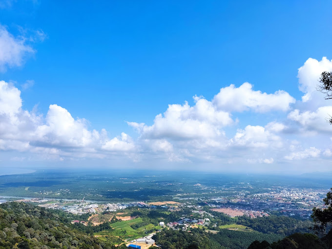
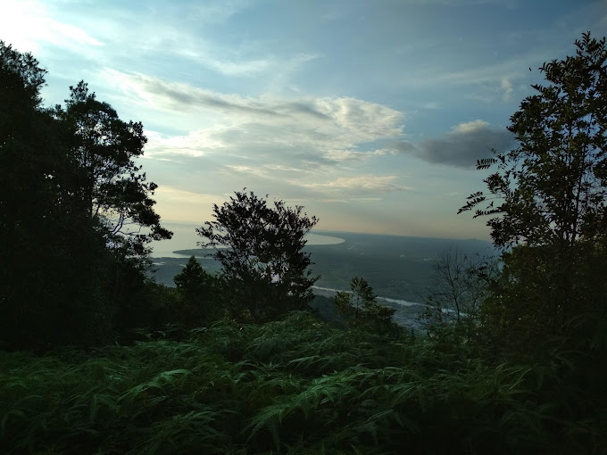
Key Viewpoints and Photo Spots: The trail is dotted with several viewpoints that offer breathtaking panoramic views. Don’t miss the chance to capture these moments. Whether it’s a selfie with the lush backdrop or a panoramic shot of the horizon, these spots are a photographer’s dream.
Flora and Fauna: The trail is alive with a diverse range of flora and fauna. Keep an eye out for exotic birds, unique plant species, and maybe even some local wildlife. Remember to respect their habitat – observe from a distance and avoid disturbing them.
Cultural Significance: [If there is any cultural or historical significance associated with Bukit Banang, mention it here. It could be related to local legends, historical events, or indigenous communities.]
Safety and Preparation: Tips for a Successful Hike
Safety should always be your top priority. Here are some tips to ensure you have a safe and enjoyable hike:
Necessary Gear and Supplies: Pack light but don’t forget the essentials – water, snacks, a first-aid kit, and a map or GPS device. Depending on the weather, you might need a raincoat or extra layers for warmth.
Safety Precautions: Stay on marked trails to avoid getting lost. Keep an eye on the weather, and be prepared to turn back if conditions worsen. If you’re not confident hiking alone, consider hiring a guide or joining a group.
Local Guidelines: Respect the trail and its surroundings. Follow the ‘Leave No Trace’ principles – take all your garbage with you, don’t disturb wildlife, and leave what you find. Check for any specific rules or restrictions before you start your hike.
Nearby Attractions: Exploring Beyond the Trail
After conquering the trail, why not explore what’s around Bukit Banang? The area offers more than just great hiking.
Accommodations and Camping Spots: For those looking to extend their stay, there are various accommodations ranging from cozy lodges to campsites close to nature. Camping near Bukit Banang can be a delightful experience under the starlit sky.
Additional Nearby Trails and Natural Attractions: The region around Bukit Banang is rich with other trails and natural attractions. If you’re up for more adventures, these nearby spots are worth exploring. They offer different experiences, from leisurely walks to more challenging hikes.
Local Cuisine and Culture: Don’t miss the local cuisine and cultural experiences. The nearby towns and villages are a hub for trying traditional dishes and experiencing local customs. It’s a great way to connect with the local community and understand the region’s heritage.
Conclusion: Why Bukit Banang is a Must-Visit for Every Hiker
And that’s a wrap on our guide to Trailhead Bukit Banang! From its challenging paths to the lush scenery and cultural richness of the surrounding area, Bukit Banang is more than just a hiking destination. It’s a journey that offers both natural beauty and a sense of accomplishment.
Recap of Highlights: We’ve covered how to get there, what to expect on the trail, and the myriad of attractions around it. Bukit Banang is an ideal spot for those who love the outdoors and are seeking an adventure that tests their limits while providing a feast for the senses.
Your Next Adventure Awaits: Whether you’re a solo explorer, with friends, or with family, Bukit Banang is a destination that caters to all. It’s a place to create lasting memories, challenge yourself, and immerse in the beauty of nature.
So, what are you waiting for? Plan your adventure, embrace the challenge, and discover the wonders of Trailhead Bukit Banang. Happy hiking, and we hope to see you on the trails!
🌟 Why Hike Bukit Banang?
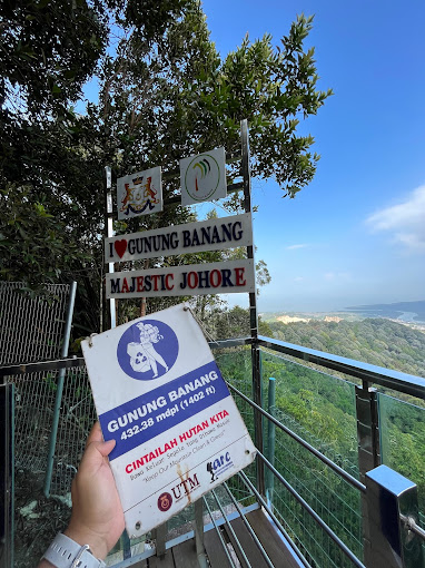
Scenic Views: From the summit, hikers can enjoy sweeping views of Batu Pahat town, Gunung Banang, and even the coastline on clear days.
Multiple Trails: Routes range from beginner-friendly paths to more challenging inclines for experienced hikers.
Local Favorite: A popular morning routine for Batu Pahat residents, making it a lively but welcoming hiking community.
Fitness & Nature: Great for cardio, family hikes, and outdoor photography.
🕒 Best Time to Hike
Early Morning (6:30 AM – 9:00 AM) → cooler weather & sunrise views.
Late Afternoon (4:30 PM – 6:30 PM) → softer light, fewer crowds.
⚠️ Avoid hiking during midday heat.
💡 Hiking Tips
Bring water & light snacks – no stalls along the trail.
Wear proper shoes as trails can be slippery after rain.
Beginner tip: Start with the easier trails, then progress to the summit route.
Respect the environment: take only photos, leave no trash.
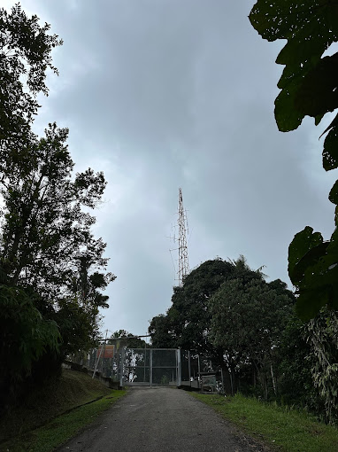
🗺️ Trailhead Location
The main trailhead is located near Taman Bukit Perdana, Batu Pahat.
Easily accessible by car; parking is available nearby.
The area is safe and usually busy with locals in the mornings.
📷 Photography Highlights
Sunrise overlooking Batu Pahat town.
Panoramic shots from the summit.
Greenery-lined trails perfect for nature lovers.
🔗 Nearby Attractions


이진하
in the last weekAs far as the difficulty for Debate the word want? East Bandung city physical activity hill training.
Haidan Rafli
4 weeks agoThe contract of those who cannot accept the fact that they cannot accept the fact that they cannot accept the fact that they cannot accept the fact that they cannot be used for this window is for this window is to give.
Tan Boon Hong
a month agoThe climb to the summit is about 3 kilometers, and most of the path is sloping. Those interested can take on the challenge.
Amar Fitri
5 months agoabu ibrohim
5 months agoEasily accessible place for hikers. Can follow tar road. Beautiful view. View; 7/10 Difficulty; 3/10